AI Revolutionizes Satellite Operations: Boosting Imaging, Data Analysis, and Space Debris Management
February 15, 2026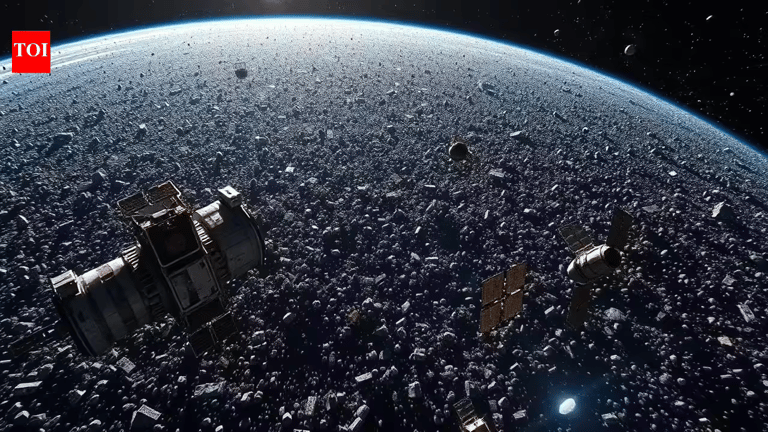
AI is expanding beyond debris tracking to enhance satellite imaging, data analysis, and geospatial applications, with significant investments in GIS and AI capabilities by Esri India and other tech firms.
Industry leaders, including senior space and tech executives, emphasize that AI is central to smarter mission design, autonomous spacecraft operation, and resilient satellite communications, enabling predictive maintenance, anomaly detection, and improved service reliability.
The article underscores AI’s growing role across space situational awareness, satellite operations, data processing, and geospatial analytics as part of India’s and the world’s evolving space capabilities.
Key figures cited include Anirudh Sharma of Digantara, Lt Gen A K Bhatt (retired) of ISpA, Awais Ahmed of Pixxel Space, Agendra Kumar of Esri India, Rupesh Kumar of Suhora Technologies, and Gautam Sharma of Viasat India.
Pixxel Space uses AI to process vast satellite imagery, with its Aurora platform integrating multiple data types to support border security, agriculture, leaks, and pollution analysis.
Pixxel Space employs AI to rapidly detect subtle changes across very high resolution, hyperspectral, SAR, and multisspectral data for applications in border security, agriculture, resource monitoring, and pollution detection.
Indian and global space players are deploying AI for space situational awareness, enabling predictive collision warnings and autonomous debris avoidance for satellites and other assets.
Digantara envisions autonomous satellite operations where satellites autonomously adjust to avoid collisions and plans to implement inter-satellite communication algorithms to enable self-learning avoidance behavior within five years.
AI is increasingly used to manage space debris and protect satellites as orbital congestion grows, with more than a million objects larger than 1 centimeter tracked to prevent collisions.
Summary based on 2 sources
Get a daily email with more AI stories
Sources

The Times Of India • Feb 14, 2026
AI powers India’s space ambitions: From debris tracking to autonomous satellites
Economic Times • Feb 14, 2026
Space domain awareness, autonomous satellites, data centres in orbit - AI opens up brave new world