China Unveils Highest-Resolution True-Color Global Map of Mars from Tianwen-1 Mission
September 2, 2024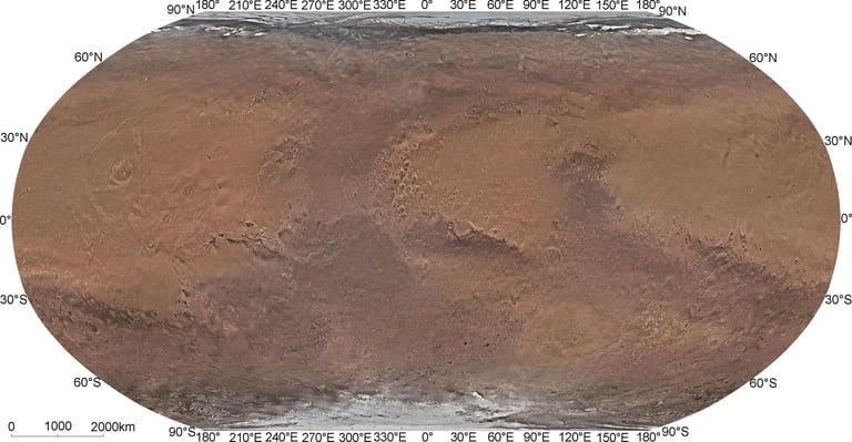
Over the course of 1,298 days, the Tianwen-1 orbiter has captured numerous remote-sensing images, culminating in the creation of the first high-resolution global color-image map of the planet.
The research team was led by Professors Li Chunlai and Zhang Rongqiao, with contributions from multiple Chinese institutions.
In July 2020, China's Tianwen-1 mission, which includes an orbiter, lander, two deployable cameras, a remote camera, and the Zhurong rover, successfully entered orbit around Mars.
The Mars Mineralogical Spectrometer played a crucial role in this endeavor, collecting 325 data strips that contributed to the map's accuracy and achieving global coverage.
This newly created map significantly surpasses the resolution of previous maps produced by other missions, which had lower spatial resolutions.
Notably, this map is the highest-resolution true-color global map of Mars to date, providing valuable data for future exploration.
Developed by researchers from the Chinese Academy of Sciences, the map serves as a potential base map for future crewed missions to Mars.
The overarching mission aims to investigate Mars's geology and atmosphere while searching for water and possible evidence of past or present life.
Additionally, the Tianwen-1 orbiter's MoRIC instrument captured 14,757 images with resolutions ranging from 57 to 197 meters, further enhancing the detail of the map.
Using advanced image processing techniques, the research team created a seamless global mosaic with a spatial resolution of 76 meters and a horizontal accuracy of 68 meters.
Summary based on 0 sources