Severe Thunderstorm Warning Issued for Parts of NC and SC; Residents Urged to Stay Indoors
June 1, 2025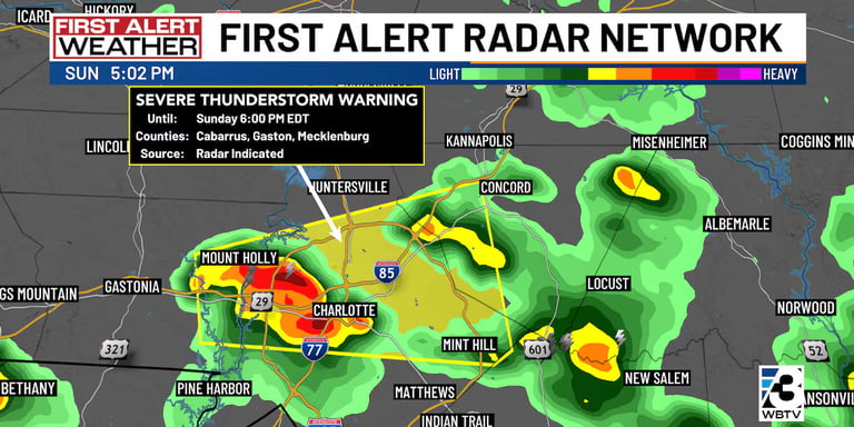
The day began calmly in Charlotte, North Carolina, with few clouds and high humidity, but a severe thunderstorm warning was issued later in the afternoon.
On June 1, 2025, at 3:28 p.m., the NWS issued a severe thunderstorm warning for Chatham, Lee, Moore, and Randolph counties, effective until 4:15 p.m.
Most of North Carolina and parts of northern South Carolina were under a marginal risk for severe weather, classified as level 1 out of 5.
A stationary front across the region has created unstable weather conditions, particularly after 3 p.m.
While rainfall is expected to be light, localized downpours and strong wind pockets could impact evening travel.
Residents are advised to seek shelter indoors during the storm due to potential hazards from gusty winds and hail.
The National Weather Service (NWS) indicated that no additional hazardous weather is expected through Saturday, although short-notice advisories may arise due to the storms.
The NWS encourages the public to report any damaging winds, hail, or flooding through designated channels.
Although the severe weather threat will diminish overnight, isolated storms may persist into the early evening hours.
Following today's thunderstorms, the NWS predicts a break from hazardous weather, with clear conditions expected from June 2 to June 7.
Real-time outage maps for power companies in North Carolina and South Carolina were made available, along with contact numbers for reporting outages.
Drivers are reminded to exercise caution during rain, including turning on headlights and avoiding flooded areas to prevent hydroplaning.
Summary based on 44 sources
Get a daily email with more US News stories
Sources

Raleigh News & Observer • Jun 1, 2025
UPDATE: Weather alert for Duplin County Sunday evening, gusts to hit 40 mph
Raleigh News & Observer • Jun 2, 2025
Pea-sized hail forecast with thunderstorms in Inland Pender Sunday, says the NWS
Raleigh News & Observer • Jun 1, 2025
UPDATE: Thunderstorms with quarter-sized hail in Cabarrus and Mecklenburg counties
Raleigh News & Observer • Jun 1, 2025
UPDATE: Thunderstorms with penny-sized hail in Bladen County